|

Sinop travel
situated on a narrow peninsula at Turkey’s
northernmost point, Sinop is like a Black Sea
island with its good-natured people and streets
where time passes slowly.

Development of the Pontic Greek Dialect
Will Pontic Greek continue to be spoken? Bortone
(2009) believes Pontic Greek spoken in the
Pontos in Asia Minor today will probably
disappear. The challenge is to keep the Pontic
Greek dialect alive. The more recent work of
researchers like Emeritus Professor Peter
Mackridge, Assistant Professor Pietro Bortone,
Dr Theofanis Malkidis, Ömer Asan, Dr Anthi
Revithiadou and Dr Vassilios Spyropoulos have
increased our knowledge of the dialect.
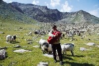
Time For to Discover the Black Sea Highlands
Discover the Black Sea
highlands in September when time is suddenly
rent by a blanket of fog or the cry of a
vulture, and make the acquaintance of nature in
its most beautiful aspect.

Formation of the First Greek Settlements in the
Pontos
According to Liddell and Scott’s An Intermediate
Greek-English Lexicon, the word Pontos stands
for the sea, especially the open sea. In time,
the word Pontos became associated with the
north-eastern portion of Asia Minor that borders
the Black Sea (see Map 1).1 The Greeks first
called the Black Sea, Aξεινος πóντος
(inhospitable, unfriendly pontos), but later it
was called Εϋξεινος πóντος (hospitable pontos)
when they became aware of its wealth in the
lands around it ...

Crypto-Christians of the Trabzon Region
of Pontos
The crypto-Christians (also called cryphi,
klosti, Stavriotes, Kromledes) were Christian
Greeks who due to the Muslim persecution against
Christians publicly declared themselves Muslims.
However, in secret, they upheld their Greek
language, customs and Christian religious
practices... | |
|
|
|
| |
|
|

Istanbul Black Sea coast travel
When you travel even the short distance from Istanbul's most
congested point to the Black Sea coast, the sea begins to undulate
in a different way, and the sky takes on a different hue. The wind
blows harder, the landscape changes, the houses are different, the
colors, the lifestyle, even the history is different. Because you
are in Istanbul, but you are also on the shores of the Black Sea.
With the Black Sea on my right, I travel to Yalıköy, an hour and a
half from Istanbul, arriving in the early morning. My sole concern
is not to miss the sunrise. I have learned that Yalıköy, like
Karaburun, is one of the Çatalca's two coastal villages and that the
population, albeit small, makes a living from fishing. Indeed, there
is a string of restaurants along the shore with menus featuring
bonito, turbot and bluefish. Podima, an ancient name meaning 'Boot',
is a village that was discovered some 200-250 years ago by pirates
and used as a place of revelry. The lower floors of the ruined
houses in the village center today were either the wine factories or
commercial offices of those original visitors. Woodcutting is of
great importance today for Yalıköy, which lies in a forested area of
eight thousand hectares. A glass factory has also operated here for
the last sixty years since the village contains silica, a raw
material used in making glass.
CAMEL WRESTLING
I leave Yalıköy and continue on my way. The road takes me to Ormanlı
Beach and from there to Karacaköy. At a higher altitude than Yalıköy,
Karacaköy is an ancient Greek village in the forest. Formerly called
Metra, it was re-named for the Ottoman governor Karaca Ahmet Pasha
after the conquest of Istanbul. Forestry has been the main source of
livelihood ever since people first settled here. Camels were used
for transporting the cut wood over the steep, rocky terrain, so
camel wrestling was also popular. Stretching from the Karacaköy
Evcik Landing to Karıncaburnu on the Sea of Marmara, the world's
second longest land wall to keep out invaders was also erected here
by.
Anastassios I between 507 and 511 B.C. And the segment of wall still
standing inside the forested area is known by its architect's name
as the Anastassios Walls. Not far from Evcik Beach, Omanlı Beach is
always windy and, with its sand walls, makes an ideal site for
paragliding.
THE HORSE FARMS AT DURUSU
After lunch I arrive at another point I've marked on my map, Durusu,
formerly Terkos, a lake amidst the trees. Connected with the Sea of
Marmara in the time of the Genoese, Durusu was notorious as a
pirates' lair. Its current residents are Bulgarian refugees and
Anatolian immigrants come to work the coal mines in the village.
Durusu Park inside the village was a resort and hunting ground in
the Ottoman period. In the Republican era it was bought up by a man
named Deli Yunus and turned into a horse farm, which it remains
today. Already in the Ottoman period Terkos Lake was used to supply
water to Istanbul. Shallow and lined with reeds, the lake in winter
is a stopover especially for migrating geese, ducks, cormorants,
swans and goldfinches.
FOREST VILLAGES ALONG THE SHORE
Continuing a few kilometers south from Terkos, I arrive at Celepköy,
another forest village. I learn that timber is felled in this
village to supply the inhabitants' need for fire wood. The surplus
is burned to make charcoal. Leaving the village and its soot behind,
I arrive at Karaburun, directly northeast of Durusu, and Turkey's
most remote outpost against the Black Sea's tempestuous waters. It
is important to the region for its lighthouse and fishermen's
harbor. It is also a village frequently visited by Istanbul
residents in search of fresh fish. From Karaburun I come to Kilyos,
the little village of Simas, aka Sarıyer. The name 'Kilyos' derives
from the Greek word 'kilya' meaning sand. Kilyos Castle, which was
captured by the Byzantines for the purpose of controlling the
straits, was last restored by Mahmud II and survives today in that
form. Again, a large part of Istanbul's water in Ottoman times was
supplied from three water towers here. A stone pier catches my eye
as.
I stroll down to the shore and I learn that this structure, built in
the 18th century, is still used by fishermen today. Since Kilyos
boasts several kilometers of natural sand beach, there is no
shortage of hotels and motels. And now that tourism has come into
its own, fishing is no longer the main source of livelihood it once
was. As for the village spirit, the biggest tree nursery here is
trying to keep it alive by holding a 'sapling' festival every
November.
THE FARTHEST POINT ON THE SHORE
When I leave Kilyos and head back to Istanbul, my last stop is
Rumelifeneri, Sarıyer's farthest point on the Black Sea coast. The
lighthouse was built in the Ottoman period at a spot known as the
'Weeping Rocks'. Even before it was built, blocks of white marble
had been erected here to guide navigators over the rocks. Rumeli
Lighthouse stands 58 meters above the water and is 30 meters tall.
It is distinguished from other lighthouses by having once been a
place of sacred pilgrimage for Greeks.
THE ANATOLIAN SIDE
Again I set out before daybreak and come to Poyrazköy to explore
today the Black Sea's Anatolian shores. As if to give the lie to its
name, which means 'North Wind Village', the north wind's chill gusts
are not felt here. The area inside the breakwater has therefore been
turned into a port that welcomes fishing boats and yachts at the
north end of the Bosphorus and entrance to the Black Sea. With the
purest sea water around, the beaches along its sheltered bay make
Poyrazköy even more touristic. Most of the village population make
their living by fishing, and you can eat freshly caught fish at the
many restaurants that line the shore. Besides its tourist
attractions, Poyrazköy is also one of the rare villages that still
sets up a market every Saturday.
After Poyrazköy my next stop is Anadolufeneri. Taking its name from
the Anatolian Lighthouse that was built here in 1834 to monitor
ships entering the Bosphorus during the Crimean War, the village is
set amidst oak and beech trees. With fishing boats in its harbor and
a few odd shops, it is smaller than Poyrazköy with a total
population of about 500. Standing 75 meters above the sea on Yon (Hrom)
Hill and 20 meters tall, Anadolu Feneri continues to greet
navigators today.
SO NEAR AND YET SO FAR
Situated on rocks with a name that means 'wild flower' in Greek,
Şile looks like a typical Black Sea fishing village. Over the years
it changed hands between the Lydians, the Galatians and the Romans,
so that its every corner harbors some historic moment. Şile is a
village permeated by legend. And the famous 'Şile bezi', a
lightweight fabric woven by the local women, is the most popular
commodity in the village bazaars and a 'must' for every wardrobe.
Towards evening I head for Şile's neighbor, Ağva. Along the way,
villages like Kabakoz, Akçakese and Kurtali astonish me by being so
near Istanbul distance-wise yet so very far in their way of life and
friendliness. Meaning a 'village between two streams' in Latin, Ağva
is situated between the Yeşilçay and the Göksu. Like Şile it has
been home to many different civilizations in the past, and was one
of the Byzantines' most remote fortified outposts. Rather
conspicuously, the hotels that line the Göksu at Ağva do not
recognize the river as a boundary but have spread to both banks, and
a tiny raft pulled by a rope attached to the bank enables guests to
move from one side of the hotel to the other and up and down the
river.
Istanbul is a beautiful city of many colors where all the seasons
can be experienced simultaneously. But the Black Sea coast offers
landscapes at least as interesting and spectacular as those of
Istanbul's Marmara, Bosphorus and Golden Horn, and at least as
steeped in history. And they are right there waiting to be
discovered.
Article and Photo:UFUK SARIŞEN
Read for travel more
Rize Travel Higlands
Istanbul’s forests and flowers
Lake Efteni, Autumn
iNFO
Istanbul hospitals and doctors
|
|
| |